

Click on map to view expanded map with Line 14 "Moscow Central Ring" as well as suburban railway lines and further projects!
METRO
Moscow became the capital of Russia and the Soviet Union after the revolution of 1917. Then it had 1.7 million inhabitants. In 2010 the city has 11.5 million inhabitants on an area of 1081 km2 (40 km from one side to the other). In 1932 construction of Moscow's metro began as a piece of art with elegant and huge stations. Today the Moscow metro seems to be the busiest in the world, carrying an average of 8-9 million passengers on a normal weekday, i.e. some 3,000,000,000 (!) a year.
The Moscow Metro is 337 km long and has 203 stations (09/2016). Although there are line numbers on some maps lines are identified by names referring to the areas they serve. There's also a 20 km long ring line connecting all other lines. The system is almost entirely underground although some lines (1, 2, 4) cross the Moskva river and line 1 also the Yauza river on a bridge. An exception is the Filyovskaya which has a longer surface section between Kievskaya and Kuntsevskaya with 7 above ground stations.
The first line opened on 15 May 1935 between Sokol'niki and Park Kul'tury with a branch to Smolenskaya which reached Kievskaya in April 1937 (crossing Moskva river on a bridge). Two more lines were opened before World War II. In March 1938 the Arbatskaya line was extended to Kurskaya station (now Arbatsko-Pokrovskaya - dark blue line). In Sept. 1938 the Gorkovsko-Zamoskvoretskaya line opened between Sokol and Teatral'naya (without Tverskaya station which was added in 1979).
The projects of the third stage of the Moscow metro were delayed during the War. Two metro sections were put into service: Teatralnaya - Avtozavodskaya (3 stations, crossing the Moskva river in a deep tunnel) and Kurskaya - Partizanskaya (ex Izmaylovskiy Park - 4 stations).
After the War construction started on the fourth stage of the metro, which included the Kol'tsevaya line and a deep part of the Arbatsko-Pokrovskaya line fromPl. Revolyutsii to Kievskaya.
The Kol'tsevaya line was planned first as a line running under the Sadovoye Koltso (Garden Ring), a boulevard ring running along the limits of 16th century Moscow. The first part of the line - from Park Kul'tury to Kurskaya (1950) is indeed situated under this boulevard. But later plans were changed and the northern part of the ring line runs 1-1.5 km outside the Sadovoye Koltso, thus providing service for 7 (out of 9) railway stations. The next part of the Kol'tsevaya line opened in 1952 (Kurskaya - Belorusskaya) and in 1954 the ring line was completed.


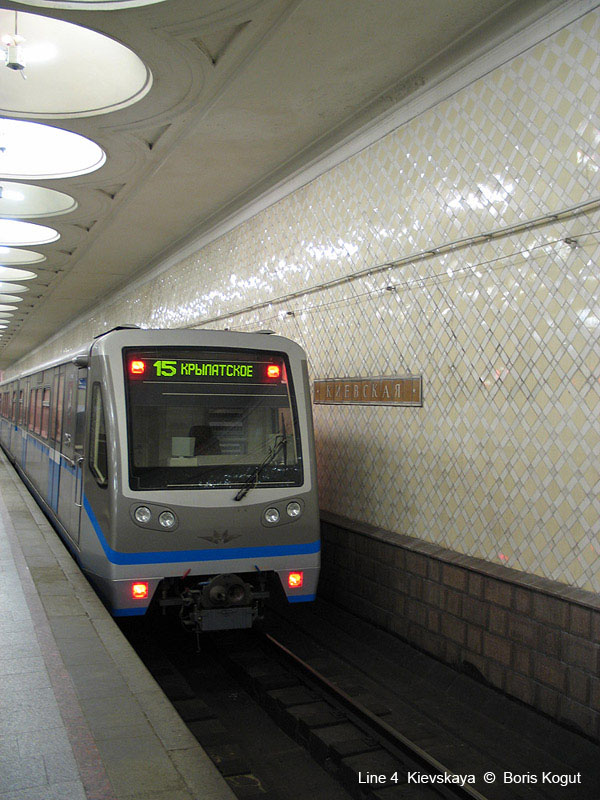


Photos © Boris Kogut
The reason for the construction of a deep part of the Arbatskaya was the beginning of the Cold War. Stations are very deep and were planned to serve for hiding people even in the case of nuclear war. After finishing the line in 1953, the upper tracks between Pl.Revolyutsii and Kievskaya were closed. In fact they were reopened in 1958 as a part of the Filyovskaya. In the further development of the metro, the term stages was not used anymore, although sometimes the stations opened in 1957-1958 are referred to as the fifth stage.
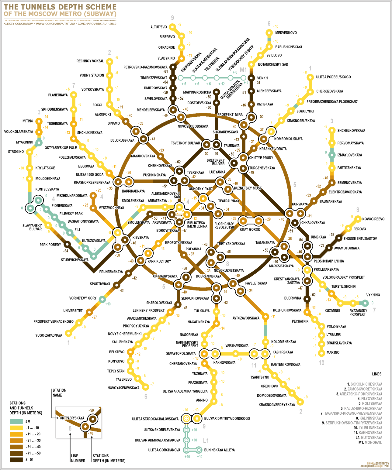
View a station by station depth map created by Alexey Goncharov
The Moscow Metro has standard Russian gauge, 1520 mm, and third rail supply. The average distance between stations is 1790 m (!), the shortest with 500 m is between Vystavochnaya and Mezhdunarodnaya (Line 4), and the longest with 6.6 km between Krylatskoye and Strogino (Line 3) . At 86 m below the surface, Park Pobedy is among the deepest stations in the world.
There are four main types of metro cars in Moscow: the oldest E-series, 81-714/7-series, "Yauza"-series, and the newest "Rusich" series. The first three have the standard length of 19 m and four doors on each side. These cars are identical to those used in all ex-Soviet metro cities (St. Petersburg, Minsk, Kyiv, Kharkiv, etc.) and in Budapest, Warsaw, and Prague. The newest articulated cars "Rusich" are employed on lines 3, 4, 5 and 12 only. While also having only four doors on each side, each articulated "Rusich" car is 27 m long.
With the exception of lines 4 and 12, all station platforms have been consistently built 162 m long in order to accommodate metro trains comprised of 8 standard cars. Presently, trains on lines 2 and 6-10 consist of the maximal possible 8 standard cars; on line 1 of 7 standard cars; and on line 11 of 6 standard cars. The newer trains on lines 3 and 5 consist of 5 articulated "Rusich" cars (about 7 standard cars in length), on line 4 of 4 articulated cars (about 6 standard cars), and on line 12 as well as the western portion of line 8 of 3 articulated cars (about 4 standard cars).
Whereas most transfer stations have two separate stations carrying two different names and connected by foot tunnels, five offer convenient cross-platform transfer, between lines 6 and 7 at Kitay-Gorod, between lines 2 and 11 at Kashirskaya, between lines 6 and 8 at Tret'yakovskaya, between lines 3 and 4 at Kuntsevskaya, and between lines 3 and 8 at Park Pobedy.
Lines
1 Sokol'nicheskaya (Kirovsko-Frunzenskaya) 22 stations - 32.6 km


More Line 1 info & photos
2 Zamoskvoretskaya 22 stations - 40.0 km


More Line 2 info & photos
3 Arbatsko-Pokrovskaya 22 stations - 45.1 km


More Line 3 info & photos
4 Filyovskaya 13 stations - 14.9 km


More Line 4 info & photos
5 Kol'tsevaya 12 stations - 19.3 km - ring line


More Line 5 info & photos
6 Kaluzhsko-Rizhskaya 24 stations - 37.9 km


More Line 6 info & photos
7 Tagansko-Krasnopresnenskaya 23 stations - 42.3 km


More Line 7 info & photos
8 Kalininskaya Eastern part: 8 stations - 16.3 km; Western part: 2 stations - 2.4 km


More Line 8 info & photos
9 Serpukhovsko-Timiryazevskaya 25 stations - 41.5 km


More Line 9 info & photos
10 Lyublinsko-Dmitrovskaya 20 stations - 32.0 km


More Line 10 info & photos
11 Kakhovskaya 3 stations - 3.4 km
Operated as a branch of Line 2 from Kashirskaya to Kakhovskaya until 1995.


More Line 11 info & photos
12 Butovskaya 7 stations - 10.0 km
"Light Metro", formerly "L1" - (90 m long platforms)


More Line 12 info & photos
13 Monorail 6 stations - 4.7 km (previously line M1)


14 Moscow Central Ring 31 stations - 54 km
S-Bahn-style circular line with initially 26 stations opened on 10 Sept 2016, with trains running every 12 minutes during off-peak periods. Abbreviated "MCC" in English for "Moscow Central Circle!. Click here to view this line on the map!
Dubrovka and Sokolinaya Gora stations opened on 11 October 2016, Koptevo on 1 November 2016, Zorge on 4 Nov 2016 and finally, Panfilovskaya on 8 Nov 2016.


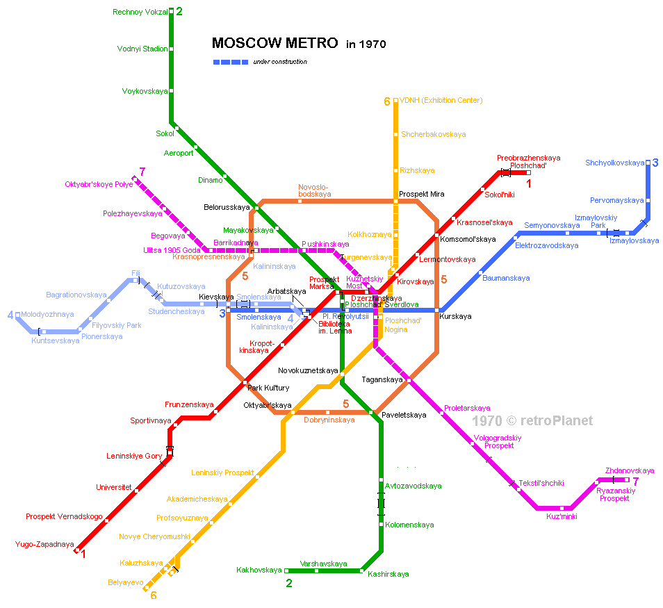
See each line for detailed history and view 1970 network map
View a chronological map created by Alexey Goncharov
Links
Moscow Metro - Official Site
Moskovskiy Transport - Official Site
Mosgortrans Moscow Urban Transport News
Metrowalks.ru - The Ultimate Photo Gallery including all Moscow metro stationsby Igor Vanin
Moscow Metro at Wikipedia
Artemiy Lebedev's extensive metro.ru site (in Russian only) incl. lots of maps(new 2003 official map)
Yuri Gridchin's Metropoliten site includes an animated history map
Mockobckoe Metpo - Moscow Metro
Moye Metro (My Metro) by Kernel32 & Grozny
Paleometro by Alexandr Mironenko
Peter Donn's Underground Stations includes excellent pictures of some stations
Various Moscow Metro Maps (by depth, chronological, etc.) by Alexey Goncharov
Moscow Metasubway station
METROCARS - Anything about Metro Trains in the ex-USSR
Voices in the Underground by Artemiy Y. Lomov
Mir Metro - Metroworld by Dmitry Aksenov, Di. Vendox and Andrey Surikov
METRO - not at first sight by Artemiy Y. Lomov
Moscow Metro Photo Collection by Bee Flowers (showing many details of city centre stations)
MosMetrostroy
Metrostroy (Metro construction) by Andrey Surikov
Moscow Monorail
Moscow Metro Track Map
Exact location of stations drawn over Google Map
urbanrail.net